The Basics
As emergency managers, you know having reliable data & products is critical when it comes to detecting inclement weather. This page will help point you in the right direction.
- Radar Program(s) - We recommend Gibson Ridge products, but others are avaible such as StormLab and RadarScope.
- Reliable Data Provider(s) - We recommend ourselves of course but we also recommend you always have a backup on hand, such as Iowa Environmental Mesonet (Level 2 only) or the National Weather Service (Level 3 only default).
- NOAA Weather Radio - We recommend Midland's WR300 AM/FM Alert Radio. As Im sure you know, you always need to be prepared during severe weather for power outages. Weather radios will help you stay notified.
The Specifics
- Data Providers (Price Range: Free - $300.00)
We recommend a Storm Hunter Subscription from AllisonHouse ($26.99/month OR $294.99/year) or check out any of our other packages. An AllisonHouse subscription is not NOT mandatory, there are free radar data providers out there for public use(Iowa State, National Weather Service, ETC...). Note: It is always a good idea to have a backup data provider on hand. - Desktop Radar Program (Price Range: $79.85 - $999.00)
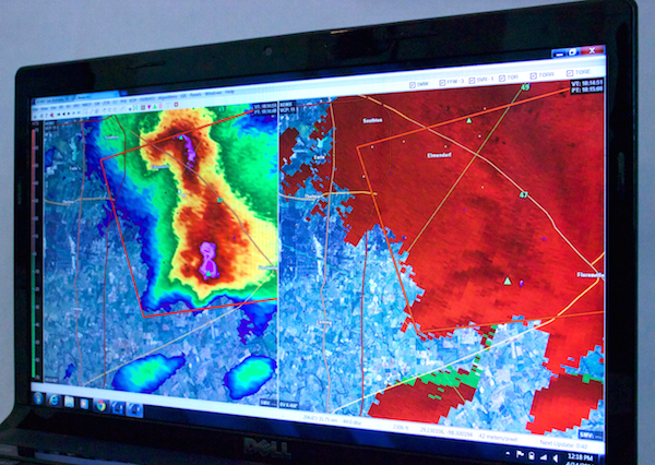
We highly recommend GRlevelx products. Out of the GRlevelx product line we recommend GRlevel3 for emergency managers. For a more detailed analysis of the storm check out GRlevel2AE. - Mobile Radars Programs (Price Range: $9.99 - $19.99)
We recommend RadarScope, but there are plenty of them out there depending on your device and platform. Examples - PKLY3 (Android), Radar Alive! (Android), and MRLevel3(Windows) - Web based radar programs (Price Range: Mostly Free)
While these programs can be helpful dectecting a storm heading your way. They are not recommended meant for a detailed analysis of the situation. - Road Shapefiles (Price Range: Mostly Free)
GRLevelX products only: Road shapefiles will really help you pin down the intersections that are being affected. There are also many other shapefiles you can load (i.e. Railroads, Stadiums, etc.) Here's a guide for Adding Shapefiles into GRlevelX Programs. - Mosaic ($26.99/per month - $250.00/per year)
We recommend GRearth. This is a great program to use to get an overall view of what is going on coast to coast. Our GRearth guide area will walk you through all the possibilities you have with this program. - Data Feeds & Placefiles (Free - $26.99/per month)
Adding data feeds feeds & placefiles to your radar program can help when tracking any dangerous situation. e.g. - If you need to know which direction the wind is carring a hazoudous chemical you can use METAR, Mesonet, & CWOP feeds to find this out.